"I Don't Kmow Where I Am Going
But I Am On My Way"
“Every turn a different scenery, after every mountain peak there is another, after every curve there is a new open view. Life is like a road, learn to take its curves, pause at junctions, stop at the red, and go at the green. You never know where it is going or who is going along with you, but it’s a journey that must be travelled no matter how challenging the roads.”
Iceland's Route 1 Road Trip.
“Never sure where the road will lead to, but I’m always confident the ride won’t be boring!”
Lurking around every curve is a stunning new Icelandic jaw-dropping scenery. From hundreds of active volcanos, massive burbling waterfalls, bubbling mud pots and hot springs, icy glaciers and rugged mountains, to scenic meadows where majestic wild horses run free! And if you are lucky, you will see and experience the breathtaking Northern lights. A photographers paradise!
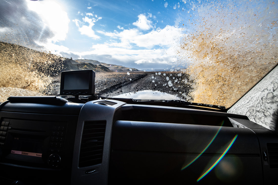
Theoretically, one could go around the island in less than two days, but there are too many must-see sights in Iceland to be in a rush. Iceland’s Ring Road ( Route 1) covers over 800 miles (1,300 Km), and self-drive tour is the best way to go. The roads are excellent and very essay to drive. Just make sure you got enough petrol, a programmed GPS, a map (just in case) and plenty of coffee. Hop in the car, roll down the windows and get ready to hit the road!
Iceland has hardly any trees, so on a bright day, the view from your car stretches towards unending picturesque roads, mountains, farms, villages, meadows and glaciers mile after mile.
Crushing through Iceland with a gang of like-minded photographers is an adventure itself. With every turn came a difference scenery, making it very hard not to stop the car to capture each unique picaresque view. The overall speed limit is 90 km/h on main roads and 50km/h in urban areas as there is more sheep than people, and they wonder freely during the summertime. Average speed while driving with photographers is 30 min stops every few kilometres.
From Iceland’s capital, Reykjavik, Route 1 leads drivers on a smooth and enchanting tour of the country. Driving counter-clockwise the first stop, and one of the most visit site is the Seljalandsfoss waterfall. This epic waterfall drops 60m and is part of the Seljalands River that has its origin in the volcano glacier Eyjafjallajokull.
Another must-see sight is the Jökulsárlón Glacial Lagoon, an attraction of broken icebergs floating with the tide, and black sand beaches.
Also along the Route 1 is the Laufskalavordur lava ridge. First impression … what’s up with the “cairns”? According to local legend, the area was a black sand desert until there was a volcanic eruption in 1948. The area got covered with rocks, and later the locals got inspired to make cairns as a ritual for good luck. Today the tradition goes on, with a little twist. There are no more loose rocks, so one steals from old cairns to make a new one!
Further on Route 1 is The Svinafellsjokull Glacier. One of my favourite sight. Known as one of the locations used in the “Interstellar” movie. The Glacier is a breathtaking frozen landscape of white and black ice broken by blue crevasses. Just like the ice, the place grips you, and does not let go!
Iceland’s Ring Road is full of natural wonders and spectacular sceneries. A playground for photographers, nature lovers and all sort of travellers. A bucket-list travel destination for everyone.
Road tripping Namibia.
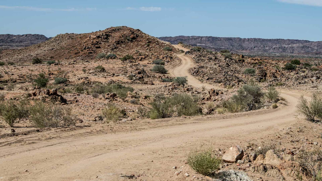
Namibia has some of the world’s most scenic roads which are also some of the most dangerous and less traveled roads in the world!
There is an epic and breath-taking drive via the C14 road through the desert from Walvis Bay to Goageb in southern Namibia. Along this road, the village of Solitaire consists of a petrol station, a little shop, a chapel and a bakery / café claiming to have the best apple cake in Namibia! It’s totally true!
D707 is a sandy, gravel track in southern Namibia, between Swakopmund and Aus.
*By now I’ve proved that the prefix “D” on Namibian roads stands for Danger or Deadly!
The D707 is 123 km long, sandy with occasional gravel, in the middle of nowhere, linking the C27 and C13 roads. It passes through remote areas, so you need to be both mechanically and mentally prepared for a truly hectic, bumpy, slippery “road” which could be generously described as “gravel!” NOTE: This route is only suitable for 4×4’s and insanely brave drivers!
C27 is a gravel and sand road of 247 km in Southwestern Namibia in the Namib Desert. This was the longest, most deserted roads which I experienced in Namibia. Driving in the middle of the road was essential to my survival, as each vehicle which passes, flings the small, sharp stones to the shoulders, so driving in the very middle of the road provides the best chance for non-skidding and drifting and will certainly save unnecessary tyre damage!
C35 is another hectically rough gravel road, running through the Damaraland … (*I tried taking one or two “D” roads to see if they would provide a more comfortable or shorter route, but they were equally as bad, or even worse.
On a positive note my “D” route detours led me to some of the Himba people, which was a highlight of the trip as I learned something about their culture and traditions. The Himba people are also wonderfully photogenic, and strongly recommended as colourful and strong subjects for any photographers.
C12. No even my experiences via the C27 and C35 could have prepared me for the C12!
From the Fish River Canyon, I stopped at a crossroad at Sesriem, as my map showed the C12 is the only route, but my modern GPS told me to take a detour of 27 km on the D545 route which never even appeared on my map! 🤔
Challenging my GPS, I decided to take the C12 instead of the D545. Not long after turning onto the C12, I realized that the D route was recommended for very good reason!
It was too late to turn back, and like everything else in life, the only way out was to push through it! Driving on that 35 km long road to hell, otherwise known C12 really scared me, and kept reminding me that there is time and a place for all of us to die, but thankfully the C12 route wasn’t the place, or my time 😉
SANI PASS: The High Mountain Pass Road in South Africa that separates the brave drivers from the wannabes.
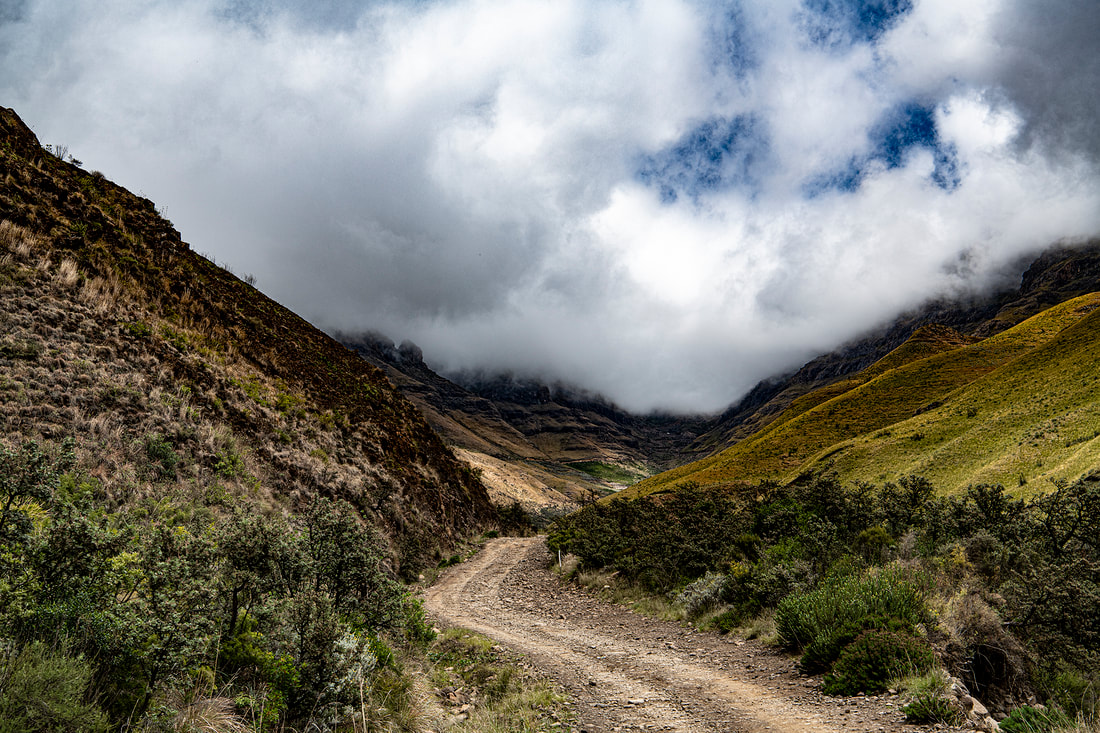
Listed as one of the most dangerous and famous hairpin roads in the world, the Sani Pass, is a zigzagging dirt road that takes visitors up and over the Southern Drakensberg Mountains into Lesotho, the ‘Kingdom in the Sky’.
IT CAN ONLY BE DRIVEN IN A 4X4
Driving up the Sani pass road into Lesotho is a daring, wild 4×4 road trip adventure. The road was built in 1950’s and remains a challenging drive throughout water potholes, narrow roads, rocks, fog, abrupt cliffs and plenty of scary twists and hairpin turns to the 2,876m above sea level top.
Most travellers leave the Underberg in the early hours of the morning and head up to the southern Drakensberg mountains for an adventurous day trip. It takes about 45 min. from the entrance of the Mkhomazi Wilderness area up to the South African Brother Post. The snaky dirt roads up to this point aren’t particularly challenging; it’s the road that follows that makes Sani Pass famous and a bucket-list road experience!
Once at the South African Post, getting through customs and immigration is quick and easy. From the SA Border Post, a 4X4 vehicle is necessary for this road, especially if the weather is poor. The road pass from this point can only be driven in a four-wheel-drive vehicle by above-average drivers, off-road motorbike or quad bike. Some even choose to leave their cars at the border and walk the last 8 km stretch to the top.
Border authorities will dictate if your vehicle is up to the challenge, as they have seen plenty of cars and drivers that did not succeed in navigating through the steep, slippery roads. Along the way, you’ll see debris from vehicles that weren’t so lucky and fail to make it safe to the top or back to the South African Border.
At 2,462m, halfway through the 8km of ‘No man’s land’, there is the notorious ‘Suicidal bend’. It has a heart-stopping panoramic view, packed with winding twists, plunging drops and tremor legs!
The Pass climbs over 800m in just under eight kilometres of length where temperatures change dramatically, and the unpredictable weather conditions increase the already challenging road condition and are the main reason for severe and often fatal accidents.
HIGHEST PUB IN AFRICA
After a steep 4×4 trail and nearly thirty switchbacks corners, it’s time to rest and enjoy the unique and breathtaking from the top with a well deserved Maluti Beer!
At the top is the Sani Mountain Lodge, the Highest Pub in Africa. The lodge offers excellent food, and accommodation to suit any budget; from upmarket and cosy Basotho rondavels to backpacking and camping facilities, a great option for those that would like to carry on exploring Lesotho the next day.
BACK ON THE ROAD TO SOUTH AFRICA
Going down the Sani Pass will test the skills, and courage, of any brave driver, and It’s certainly not for anyone afraid of highs or with fear of landslides. Fog will add to the challenge and fun while bouncing over rocks and trenches. The road is full of holes, loose rocks, gravel and hairpin bends that will give you an adrenaline rush, and make your stomach turn when you look over the side and see the drops to which you could fall if you made a flimsy miscalculation. Nevertheless, Sani Pass has been the best adventurous road experience I’ve ever had!!
Join LensTraveller On A Journey Of Discovery. Stay updated with the latest travel adventures, inspirations and insights.
*By subscribing you agree to our Terms &Conditions and Privacy & Cookies Policy.


